
Whitefish Future Land Use Scenarios Open House
The City of Whitefish and consulting firm, czb LLC, hosted an open house on Tuesday, November 18, 2025 to share their results from visioning sessions in September. This blog post will share the boards that were posted around the room and will do its best to explain what they show.
There will be an online component for this activity to accommodate those who were unable to attend in person, however, this has not yet been posted. We expect that this activity will be posted here when it is available.
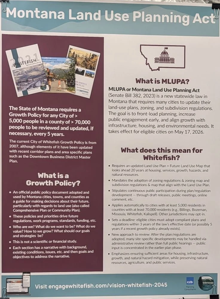
Board #1 - The Montana Land Use Planning Act
See our blog post summarizing the Montana Land Use Planning Act by clicking here.
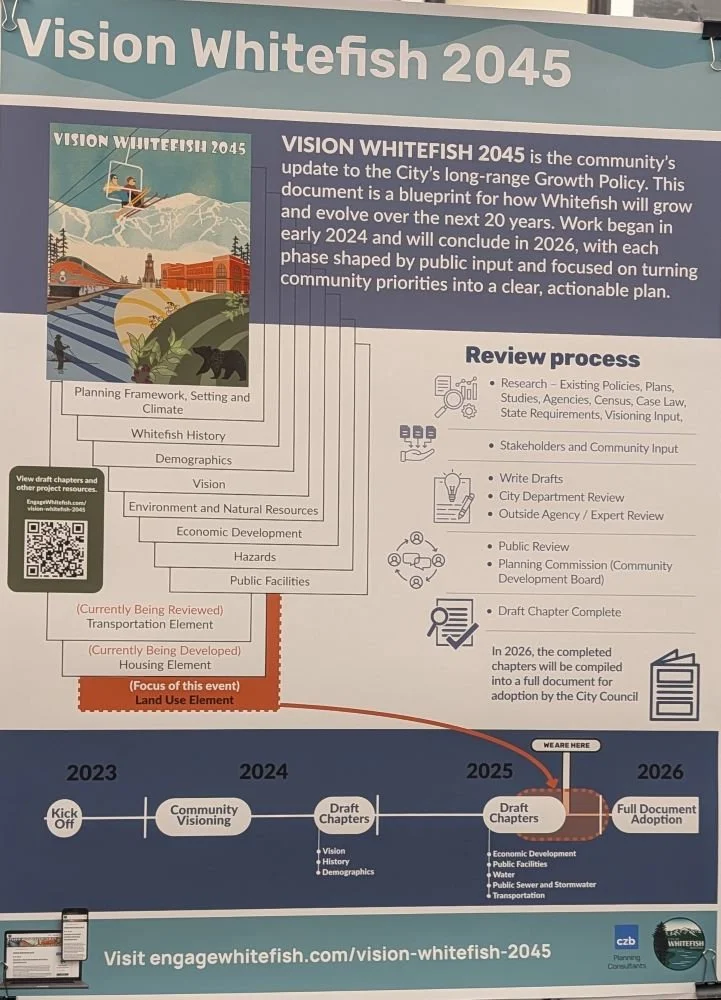
Board #2 - Vision Whitefish 2045
Vision Whitefish 2045 is the city’s Land Use Plan process to comply with the Montana Land Use Planning Act. View the city’s engagement website for Vision Whitefish 2045 by clicking here. This poster lays out the elements and the timeline for completing this process.
Board #3 - Land Use Element Process
The Land Use Element of the Land Use Plan is the basis for how and where Whitefish will grow in the future. This element will describe how residents currently view various areas of the city, will set a clear growth vision for where and how the city wants to grow, and will look at the city’s current capacity for growth to find needs related to infrastructure projects and funding. This element will also recommend possible zoning changes that the city can implement to streamline permits and improve housing affordability.

Board #4 - What the community said [during the february, april, and september visioning sessions and online]
The in-person sessions were attended by ~150 people, with 150 people also completing the online component. Livable Flathead was in attendance for many of these sessions, and saw many of the same people in the room, meaning that the total attendance across all sessions was likely more than 150 people, though not significantly more.
Some key themes emerged as noted on the poster, including:
The Highway 93/40 intersection is seen as the initial “gateway” into Whitefish from the South.
The downtown area is valued by many residents, though there was recognition that some change in this area was likely.
Emergency access routes are a concern for some residents, especially those on the northern side of the viaduct.
Traffic congestion along Highway 93 and Wisconsin Avenue is a problem that was noted.
Affordable and workforce housing continues to be expressed as a top priority by residents.
Editorial note: this is a top priority of Livable Flathead also, and our Land Use Element, Future Land Use Map, and updated zoning code will be incredibly important to get right if Whitefish is ever going to be successful in achieving this goal.

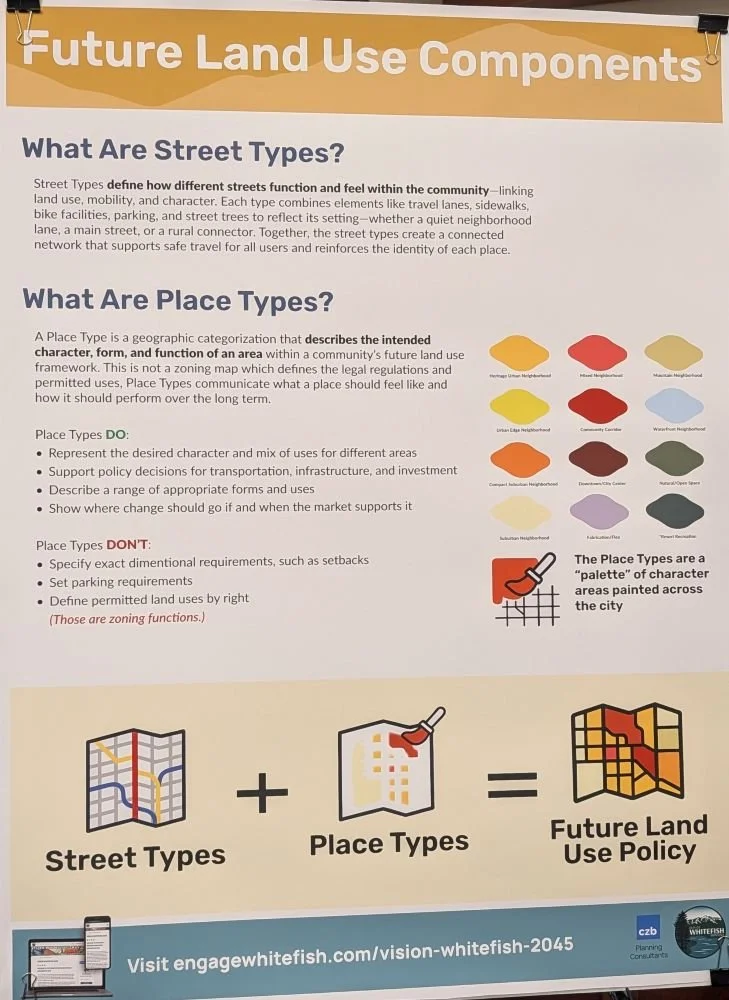
Board #5 - future land use components
This board provides the definitions for “street types” and “place types” which were the focus of the September visioning sessions.
Street Types:
Define the function and feel of different streets in the community.
Place Types:
Describe the intended character, form, and function of an area in the framework of a Land Use Plan.
Editorial note: this is not zoning, which is separate, but rather how a specific part of the city functions and feels.
Ultimately, this will lead to updates of zoning ordinances in the City of Whitefish. This structure is the basis for a form-based zoning code, rather than a zoning code that is simply defined by separation of uses. Read more about form-based zoning codes by clicking here.
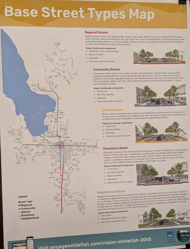
Boards #6 and #7 - Base Street Types map and base place types map
These boards describe the results from the September visioning sessions, specifically:
Street Types
US-93, South of 13th St was identified as a “Regional Street” accommodating the highest traffic volumes and speeds.
Spokane Ave, 2nd St, Baker Ave, and Wisconsin Ave were identified as “Community Streets” which feature lower traffic volumes and speeds than regional streets.
13th St/Columbia Ave to 7th St, 7th St, Pine Ave, Colorado Ave, and Karrow Ave/7th St were identified as “District Streets” which tend to cater more toward residential and neighborhood uses.
The downtown grid (in purple on the below map) was identified as “Downtown Streets” which are the streets with the most urban context.
All other city streets were identified as “Neighborhood Streets” which carry the lowest traffic volumes and speeds and are primarily found in a residential neighborhood context.
Place Types
There were many different place types identified throughout the city during the visioning exercises. Reference the map below and the following posters for descriptions and locations of the identified place types.

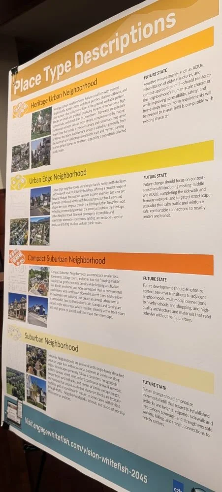
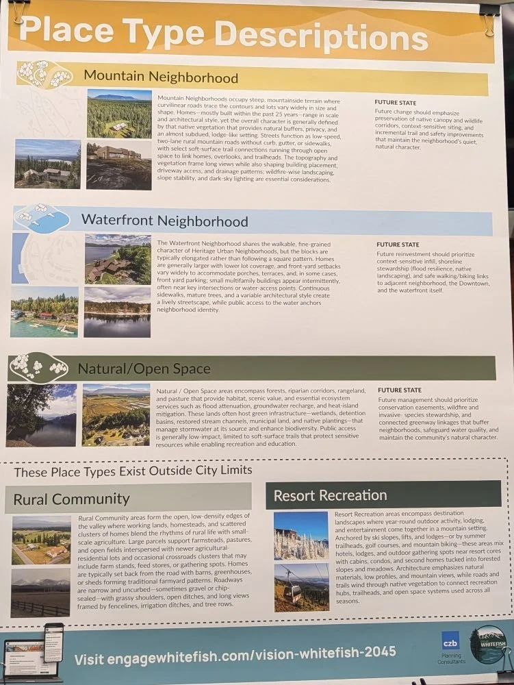
Boards #8, #9, and #10 - Place type descriptions
Read below for descriptions of the place types that are identified on the “Place Types” map above.

Board #11 - How and where should [whitefish] grow?
Based on an estimate of 2,076 new homes needed by 2045, how should Whitefish accommodate these needs? This was the focus of the open house on November 18 — to identify potential locations and types of development that the community feels would best accommodate this future growth.
Editorial note: This poster contends that a “full buildout” inside Whitefish’s current city limits (based on the Base Place Types Map above) would yield only 1,100 homes. However, this is only assessing lots that are currently vacant. We at Livable Flathead think that there is considerable opportunity to increase this number when redevelopment occurs on other lots within the city, either when older homes are replaced or by adding more homes to a lot that already contains a home. Stay tuned for future blog posts that dive into this idea more.

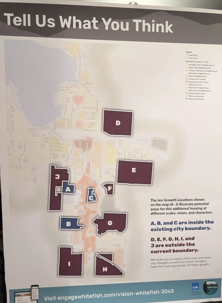
Board #12 - Identified areas [with large amounts of vacant land] for potential future growth
The following posters will show where attendees placed stickers to identify their preferences for both location and place type based on the identified areas on the map below, which represent areas both inside (blue) and outside (purple) of the current Whitefish city limits.
Boards #13 and #14 - Possibilities inside of the city limits
Attendees expressed the following preferences (in order, starting with most preferred):
Location C (Mountain Mall Area), Neighborhood Center
“Neighborhood Center” is a place type that does not currently exist in Whitefish and are characterized by compact, walkable districts that blend a full range of home types with neighborhood-serving retail, restaurant(s), services, and small civic spaces.
Location C, Compact Suburban Neighborhood
“Compact Suburban Neighborhood” is a place type that accommodates smaller lots, townhomes, cottage courts, and other low-rise “missing middle” homes that gently increases density while keeping a suburban feel.
Location B (West of US-93 between JP Road and Park Knoll Lane), Mixed Neighborhood
“Mixed Neighborhood” is a place type that features a diverse blend of home types — single-family, duplexes, townhomes, small multifamily, and select neighborhood-serving commercial uses like a coffee shop, restaurant, or others that provide daily needs close to home.


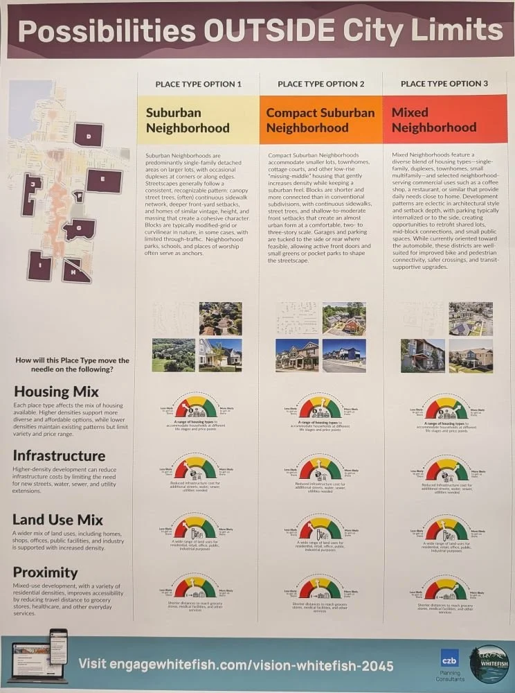
Boards #15 and #16 - Possibilities outside of the city limits
Attendees expressed the following preferences (in order, starting with most preferred):
Location J (Along Karrow Ave, South of 7th St W), Mixed Neighborhood
“Mixed Neighborhood” is a place type that features a diverse blend of home types — single-family, duplexes, townhomes, small multifamily, and select neighborhood-serving commercial uses like a coffee shop, restaurant, or others that provide daily needs close to home.
Location E (Between Armory Rd and Voerman Rd), Compact Suburban Neighborhood
“Compact Suburban Neighborhood” is a place type that accommodates smaller lots, townhomes, cottage courts, and other low-rise “missing middle” homes that gently increases density while keeping a suburban feel.
Location D (North of Edgewood Dr and East of Texas Ave), Compact Suburban Neighborhood

Board #17 - Other places where it makes sense to accommodate future growth
While there is a large variety of areas identified on this map, we see two distinct clusters:
South of Voerman Rd to Monegan Rd (South of Location E that was identified by the consultants)
“The Avenues” — Spokane Ave, Kalispell Ave, Columbia Ave, Somers Ave
This is interesting as it is somewhat in opposition to feedback gathered during the September visioning sessions which identified this area as one that would likely stay mostly the same over the next 20 years.

Board #18 - open space for additional comments
Attendees wrote down and posted additional comments on post-it notes with other feedback. View these on the poster below.
